|
The
following comprehensive and well researched addition to the WEATHER SHIPS page, North American version, is kindly provided
by Jerry Proc.
NORTH AMERICAN WEATHER
SHIPS
In 1946, the major political
powers convened in London in order to form a international network of Ocean Weather stations in support of the newly emerging
airline industry flying transoceanic routes. Of the 17 stations established, the United States would provide services
for 11 with Canada having 2 stations up to 1950 and only one thereafter.
This is the story of
the Canadian stations Baker and Papa. Most of the photos are linked to a table at the bottom of the document. http://jproc.ca/rrp/wxship.html
BRITISH OCEAN WEATHER SHIPS
The following short description references the Ocean Weather Service before the advent of satellite
communications. John Van Dyke was a wireless operator and has provided the pictures and text which offer an insight
to this important service to both marine and aviation up to the middle of the last century. It all seems a long
time ago now but there may still be readers who will recall this service and have stories to tell of their own time
being thrown around in their bunk whilst 'on station' in the North Atlantic.
Also, Mike Walling's account of this service from 1940 to 1945 follows John's
article.
|
|
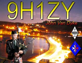
| JOHN "THE PIPER" WINTER VACATIONING ON MALTA |
John Van Dyke, Amateur Radio calls GM0RYD / 9H1ZY, attended I.C.A.O.college, Bletchley Park
from 1956 to 1957 and was qualifed as Communications Officer. John spent time at Birdlip Radio Station 1957-1958 as
a Transatlantic H.F. Operator and at Prestwick Airport from 1953 to 1959. The job involved Air Traffic Control
work as an Oceanic Operator. His sea time was spent as Radio Operator aboard Ocean Weather Service Vessel "WEATHER
REPORTER", radio call sign MYDN from 1960 to 1975 . He is currently a Member of Royal Naval Amateur Radio Society
and the Malta Amateur Radio League.
While at 'home' in Largs, Scotland during the summer months of May to August his call sign is
GM0RYD. To get away from the often wet climate of Western Scotland he winters on the island of Malta and uses the call
sign 9H1ZY . John's son Gordon and family including two grandchildren are resident in Villa
Rica, Georgia USA. When on a visit to the U.S. John uses the amateur radio call sign prefix W4 during the months
of June and July. John speaks |Gaelic and is an accomplished player of the bagpipes. He is often asked to perform
at various functions on the Island of Malta such as St. Andrew's Day, Burn's Suppers while also teaching young and old
the 'secret' of the pipes.
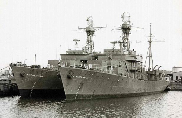
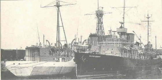
The "WEATHER REPORTER" and "WEATHER ADVISOR" are pictured below at their berth
at the Ocean Weather Base in Greenock on the River Clyde in the fifties.
The Ocean Weather Service was created in 1947, and employed 10 ships . 4 British,
2 French, 2 Dutch, and 2 Norwegian,
The international Civil Aviation Organisation were the governing body. They decided
to cover the North Atlantic with the following Ocean Weather Stations
European manned stations
4YA... 62North
33 West
4YI....58 North 19West
4YJ. 52 North 20 West
4YK..45 North 16 West
4YM.
was stationed between Norway and the Faroes and was manned by Norwegian Ships.
U.S. and Canada had ships in the Western
Atlantic and Eastern Pacific Oceans.
The stations were established to gather weather information, and to act as Rescue vessels for both Aircraft
and Shipping.
The ship would remain on Station for 23 days, during which time it would launch a radio sonde balloon,
at 0000GMT and 1200 GMT, observing the variations in humidity, temperature and air pressure, this was transmitted to the ship
and transposed for transmission to land stations. At 0600 and 1800 an upper air balloon was launched to record the upper
air winds normally up to a height of 40,000 ft. This information was then transmitted as a CQ on 2 Frequencies simultaneously,
a QSL was received from GFT (Dunstable U.K.) and from NMH (Washington DC.) when on station Alpha
An actual weather
report was transmitted every hour on H.F. and a listening watch on 500KCS gathered the weather observations from passing Merchant
Vessels.
British ships were leased from the Royal Navy and still had some of the armament in place, (not armed) plus an
impressive aerial array, 4 H.F Whips, 2 M.F. wire antennas assorted vertical wires, 2 VHF and 2 U.H.F. Bird Cages!!!
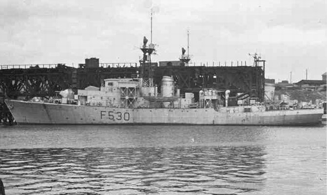
Above, the "OAKHAM CASTLE". She was a typical vessel purchased from the
Royal Navy for the Weather Service having once spent her time escorting merchant ships on the North Atlantic during WW2.
During the Cold War, we were often shadowed by Russian Trawlers!!!
The crew signed articles and
came under the Merchant Navy Shipping Act.
The Meteorological Staff were employed by the Air Ministry and listed as supernumeries.
The
Radio Operators were 6 in number, 2 per watch when on station.
Aeronautical operator
H.F.
North Atlantic
Radio Telephone
V.H.F
121.5 and 126.7 Mcs, manual V.D.F
U.H.F
243Mcs (Military)
Aircraft
flying the Atlantic would request the following information
Ship's QTH , Radar Fix, Winds Aloft, and often a QSP of their
position report via H.F. to Oceanic Control Station either Shanwick or Gander.
Maritime Operator
H.F.
Broadcasts
on the hour Actuals, every Six hours Upper Air Reports. Also responsible for Commercial Traffic.
M.F.
Guarding
500Kcs, Broadcast Warnings to shipping, and the normal Commercial Traffic
Guarding 2182Kcs and 3023kcs (Military)
Updating
the position co-ordinates on the NDB radiating between 370 and 380kcs according to Station
In the late 50's, jet aircraft made their appearance crossing the Atlantic in 6 or 7 hours using Radio Telephone
for the position reports and Air traffic advisory No R.O.
Radioteleprinting came on line between
Control Centres.
Redundant Communications staff were either posted as Teleprinter Operators or were made redundant.
I
was made redundant in 1959 and joined the Ocean Weather Service in 1960. I joined the "Weather Reporter"/MYDN ex- H.M.S. Oakham
Castle, a Castle Class Corvette built in 1944
of 1,200 tons length 252 feet , and took part in the Battle of the Atlantic.
I
remained in that service until once again redundant in 1975. (the demise of morse key operated radio was ongoing)
For
much the same reason, The Jet aircraft were using sophisticated navigational equipment, and they were more reliable from a
engineering point of view than the propeller driven aircaft.
Weather Observations were now sent directly to GFT (Central
Forecasting Office U.K.) by either Fax or RTTY. .
Life aboard an Ocean Weather Station was
for the most part routine, except when we received mail courtesy of R.A.F Coastal Command. The Shackleton Aircraft
performed weather observations over the Eastern North Atlantic, and mail ws collected at their base, it was dropped in a canister,
with a drogue parachute attached, it survived the impact, I am glad to say.
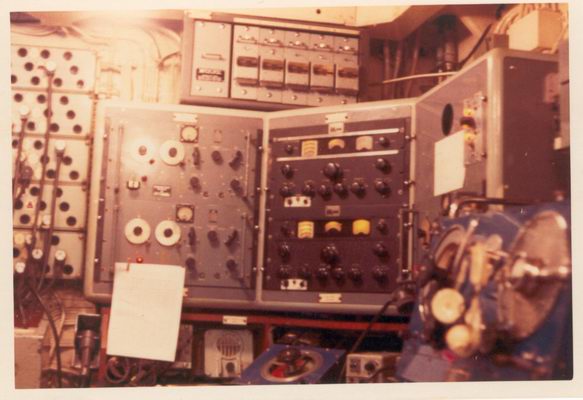
|
|
| OCEAN WEATHER SHIP W/T OFFICE |
The busiest station was Ocean Station Juliet, it was on the transatlantic shipping lane, and a favoured
route of the commercial aircraft.
Quietest, and coldest was Ocean Station Alpha, although we did get involved with
the Cod War in the 70's, Broadcasting Warnings to to trawlers in the vicinity of the Icelandic Waters.
My personal
story
I was 1957-9 a Communications Officer at the Oceanic Control Centre at Prestwick , Scotland.
Operating mostly
C.W. The aircraft in those days carried an R.O. and position reports and weather information were exchanged.
Flight
information, between Oceanic Airways Control Areas, Prestwick MBY. Gander VFG, New York WSY, and Iceland TFW also to the South.
Santa Maria CSZ were carried out on various C.W. frequencies depending on conditions.
We had several alerts concerning aircraft, the propeller driven aircraft were prone to engine failure, and
if one engine went out, would either divert or return to point of departure, a close raio watch would be kept in this case.
We
had two ditching , both involved single engined aircraft.
Firstly anAmerican Sabre Jet, on flight from Texas to Norway.
A
flight of six departed for the crossing, they had to take on fuel in flight, the last re-fuelling took place about 100nm south
of the Station, One of the aircraft was unable to achieved re-fuel and ditched.
Normally the Ocean Station
would be alerted whenever a flight of this nature was to take place, it did not happen.
An alert was eventually received,
and a Rescue Aircraft from the U.S.A.F. base at Santa Maria in the Azores arrived on scene and located the downed pilot.
Unfortunately,
his ejection from the plane was not successful causing his emergency beacon to become damaged, thereby extending the rescue
to 12 hours, and the pilot died of exhaustion.
The next Rescue was more successful, although it had it's hairy moments.
A
flight of four single engined aircraft, on a delivery flight from Gander VFG to South Africa via Santa Maria CSZ, The flight
had originated from Los Angeles LAX, and had re-fueled at Gander for the crossing.
On first contact only three aircraft
appeared on the radar screen, and the O.S. was informed that the fourth aircraft was 30 minutes flying time behind.
The
fourth aircraft made contact, but did not appear on the screen, Radio Contact was very scratchy on VHF, The Pilot was
quite confident that he was on track, ater being informed that he was on the qrong heading.
Radio contact was lost, and
an hour lagter the Alert came out from O.A.C. that the aircraft was overdue at Azores.
The ship immediately headed South,
and a rescue aircraft from Santa Maria located the flight. And decided due to the fuel situation, the best course was
to head for the Ocean Station.
The flight had compass failure, and was guided to the ship. Where a foam flare
path had been laid in readiness.
However the pilot ditched 20 nm short of the flare path, ater having trouble
opening the canopy ready for ditching.
On arrival the ships launch was able to go alongside the dinghy and the pilot
was rescued without even getting wet, he was grateful of course, but slightly disappointed when he realised, he would be a
guest of The Queen until we docked in Greenock Scotland 10 days later.
Our commercial traffic tally went up considerably
for that voyage!!!! (He was a professional airline pilot on vacation)
Two ships remained after 1975, carrying 3 Meteorologists
and one Radio Officer
The Service was terminated in 1980, by which time the Weather Satellites were in orbit, Forecasting
the weather had entered another stage.
Ocean Weather Stations 1940 – 1945
By Mike Walling, www.mikewalling.com
The ocean weather
station concept originated in the early days of radio communications and trans-oceanic aviation. As early as 1921, the Director
of the French Meteorological Service proposed establishing a stationary weather observing ship in the North Atlantic to benefit
merchant shipping and the anticipated inauguration of trans-Atlantic air service. Up to then, temporary stations had been
set up for special purposes such as the US Navy NC-4 trans-Atlantic flight in 1919 and the ill-fated Amelia Earhart Pacific
flight in 1937.
Coast Guard officers Lieutenant D. E. McKay and
Captain G. B. Gelly first became interested in oceangoing weather stations after a Pan American Airways survey plane, piloted
by aviation pioneer Eddie Musick, went down in a tropical storm while exploring a route from Hawaii to Australia.
A series of experiments with weather balloons;
some launched from Boston Harbor and others from cutters on International Ice Patrol in the North Atlantic, demonstrated the
value of weather forecasts based on information gathered at sea. Captain Gelly, taking advantage of the Washington grapevine, leaked the test results to a friend who had the ear of President
Franklin D. Roosevelt. The President, late in 1939, directed Admiral Russel R.
Waesche, Commandant of the Coast Guard, to set up a weather observation service in the North Atlantic.
When World War II
began in Europe on September 1, 1939, surface weather reports which had normally been made
by trans-Atlantic shipping were discontinued because of the radio silence imposed on merchant shipping. Thus, no weather reports
at all were being received from the North Atlantic Ocean area. In peacetime merchant ships
broadcast important local weather conditions to other ships and to shore stations. To
do so during war invited death from hunting U-boats and armed merchant raiders.
At the same time, American flag transoceanic
flying, at this point done exclusively by Pan American Airways Boeing 314 flying boats and British Overseas Airways Corporation
(BOAC) also flying B-314s, was increasing. This activity required complete and
accurate weather information thus engendering the need for strategically placed ships which could provide the necessary meteorological
data. The use of Coast Guard cutters to gather weather data was a logical result of the expansion of transoceanic air travel
on the eve of World War II.
In January 1940, the Coast Guard in cooperation with the Weather
Observation Service
was authorized by President Franklin Roosevelt to use its 327 foot Secretary Class cutters to establish an Atlantic Weather
Observation Service.
On February 10, 1940, the Coast Guard cutters
Bibb and Duane assumed Weather Station
1 roughly 600 miles northeast of Bermuda and Station 2 located roughly 800 mile southwest of the Azores.
Their daily weather reports were designed primarily for the protection of the rapidly increasing trans-Atlantic air commerce. The cutters were always on station when Pan American Airways American Clipper, Dixie Clipper or Yankee
Clipper passed to or from Bermuda and the Azores.
By July 1942, the
first fighter planes were also being flown across the Atlantic by way of a chain of U. S.
airbases stretching from Labrador across to Greenland onto Iceland and
finally England. Two more Coast Guard-manned
plane guard (rescue) and weather stations, one midway between Labrador and Greenland in Davis Strait and the other in Denmark
Strait between southern Greenland and Iceland where established (plane guard stations “A” and “B”).
Just prior to the invasion of Normandy in June
1944, three additional ocean weather stations were located in blank areas far out in the mid-Atlantic and the British Navy
established one ship weather station about 50 miles west of the British Isles.
On October 21, 1944, eight more weather stations
including two plane guard stations were established. During 1944 the total number of flights across the North
Atlantic waters was over 20,000, or an average of fifty–four flights per day. The successful North Atlantic flights in 1944 depended primarily on accurate meteorological forecasting. Planes moved
or stopped on the signal of the airdrome weather officer. His decision was based
on reports from the ocean weather station ships.
By the end of World War II in Europe
in May 1945, a total of sixteen stations had been established north of 15° Latitude to give adequate weather observation and
air sea rescue facilities. Six more were between the equator and 15° N in the Atlantic. Eleven of these stations were operated by a task force of twenty-six frigates based
regularly at Naval Operating Base, Argentia, Newfoundland,
and rotating on schedule that permitted visits Bermuda, Greenland, Iceland
and Boston.
In 1943, the US
Navy Commander in Chief (COMINCH) directed the Commander Pacific (COMPAC) to establish two weather reporting stations. These
were established north of the Hawaiian Islands and in the Gulf of Alaska. Later that year
three plane guard stations began reporting weather.
As the Navy moved westward there were established
additional weather reporting and plane guard stations. The weather reporting stations were off routes normally flown by aircraft
while plane guard vessels were on such routes. In general the plane guard vessels made the same reports as did the weather
reporting vessels. On January 1, 1946, there were a total of twenty-four weather and plane guard stations.
Parts excerpted from The
Story of the Coast Guard Weather Stations by Bernard C. Natly and Truman R. Strobridge, US Coast Guard Academy Alumni
Bulletin, March/April 1974, Vol. XXXXI. No. 2. Reprinted with permission.
A more comprehensive site addressing the Ocean Weather Ship service may be found at
Paul's www.weatherships.co.uk.
Many pictures of crew members are also shown with a variety of pictures taken aboard
the vessels when in active service.
|